Tuesday, July 31, 2007

Pikes Peak

On Saturday the 14th Ryan and I completed our 4th 14er. We climbed the ever popular Pikes Peak, which was the most challenging so far. We went up the northwest slope / Crags Campground route, which starts from 10,100 feet and climbs to 14,110 ft over 5.25 miles. The trailhead is extremely easy to climb and follow except for the area around 13,200 ft. The photos in the route description help out there. The trail starts out rather gently and then cranks up the difficulty from the .5 mile to the 2.5 mile mark. You gain most of the 4000 ft in those 2 miles, but past there you find a welcomed flat (valley?) area that lasts for almost 2 miles. I actually jogged parts of that flat stretch (partly to catch up to Ryan but mostly to push my body and see if I could jog at 13,000 ft), which the church leadership group (of ~75 kids!) called the "sound of music" part of the hike. I really enjoyed seeing the orange-red sandstone rocks compared to the other mountains of this summer.

It was fairly cloudy and 38 degrees at the top, so we didn't stay long. It might have also had something to do with the fact that there were cars and people everywhere. [I definitely know I am a solitude snob... but SERIOUSLY, it was a zoo up there.] Note that aside from the church group mentioned above, the trail to the top was relatively quiet, so I would imagine this would be a serene hike on a weekday. Ryan and I both made good time and felt really good (but exhausted) after the 11 miles roundtrip. We actually did so well that we both ended up pawning most of our water and PowerAde on members of the church group struggling to get to the top as we passed them on our way down... which brings me to my next point.

[lecture start]
Leaders of large groups should NEVER assume their group members are capable of knowing what they need to climb a mountain or are acclimated and able to climb a mountain after getting off the plane from St. Louis the day before. No-no's:
  • We passed a girl less than a mile into the hike complaining that she felt like crap and couldn't make it much further. Instead of listening to her, her fellow hikers basically told her she was fine and pushed her on. I assume she made it ok, but that doesn't mean she should have continued. She could have easily had altitude sickness and passed out 2 miles from the road.
  • On our way down we passed kids who were out of water with 1,000 ft of elevation still to gain. I gave away a liter of PowerAde and a lot of water. Ryan gave away at least that. I don't know who thought a 20 oz bottle of water would suffice, but that's just dumb. Look at how many times the word "water" is used at http://www.wikihow.com/Climb-a-14er.
  • It was cloudy, and there was no way the stragglers were going to make it to the top by noon. I doubt the whole group was done by 3pm.
Kudos to the kids who made it up, but un-kudos to the leaders for not properly assessing the group prior to sending them up the hill.
[lecture end]

But I digress... here is our summit photo -

Now we're halfway (3 of 6) done with the Front Range's 14ers! 49 more to go in all :)

We stopped by Garden of the Gods but decided that would need to devote another day to that park. When we made it back to Denver we cleaned up and headed to the Black Angus to devour beef and potatoes. Afterwards I pondered how many hiking miles my Vasque Sundowner boots have carried me now that they're 10 years young. I think I decided a good bare-minimum estimate is 300 miles (at least 50 miles this summer, 50 miles last summer in the Smokies, 30 miles (approx ?) in the Olympics and Rainier area in Washington, at least 100 miles on various MUOAC trips at Miami, etc). Woohoo! Those boots are the best gear purchase I've made so far, with my Mountain Hardwear Windstopper Jacket coming in a somewhat close second. I have only had 1 blister in all those miles. I guess it's true - Whatever you do, take care of your shoes (Phish Cavern reference anyone?).

Monday, July 30, 2007

my cat climbs mountains too

I have to admit that I have up to this point *hiked* and not *climbed* mountains, it's still more common so say you have climbed a mountain rather than hiked to the summit. Anyways, I'll get to climbing soon enough... perhaps it would also be more accurate then to say that Tacoma *jumps* his mountains since that seems to be his preferred method. Whatever the correct term, here's proof of his desire to get at close to the sun as possible just like me:

He jumps from the stereo (not the stacked speaker) to get on top of the kitchen cabinets. I wish I could jump with no running start and accurately land on a platform four times my height (assuming he is 9 inches tall and the cabinets are 36 inches tall). That would make me able to land on my feet roughly 22 feet above where I jumped standing flat from. Maybe I can find something at Whole Foods to help me get there...

Monday, July 9, 2007

Bear Peak and Bighorn in Guanella Pass [catching up]

On May 19 Ryan and I decided to hike to the highest point in Boulder to help us get acclimated to elevations we were hoping to exceed by climbing some 14ers. The highest point in Boulder is Bear Peak, at 8,461 ft above where the ocean stops and the terra firma starts. It's the tallest point on the left side of the *very* attractive photo below, taken several miles east of Boulder:

We started in the early afternoon from the NCAR parking lot. I wish we would have read this (see Astertiki for full description) before our journey began:
Fern Canyon is a very steep climb and as such is much shorter. The climb is goes up 2100 vertical feet in 1.4 miles. It goes almost straight up Fern Canyon and then straight up the a ridge to get to the peak.
Another account of this hike can be found at http://www.thedenverchannel.com/discovercolorado/13404382/detail.html. Having not read either of the above and simply looking at a map with a slight concern that it was already mid-afternoon, we decided to take the shortest route to the top. I'll cut right to the chase and tell you the middle section of this hike is probably the steepest hiking I've ever done... as in steep steps carved out of the rock to gain at least a foot of elevation with each step.

The trail starts with a very mild ascent and then dips down through a quaint valley to cross Bear Creek. The trail then heads up moderately towards Fern Canyon. When we got to the Fern Canyon trail split most of the other people around us decided the afternoon rain was not going to hold off and advised us to turn around. We made the correct assumption that the lightning was far enough away (and moving further away), so we pressed on. That was when the fun began. If you do decide to follow this trail and you're winded before you get to Fern Canyon, you should either turn around or make sure you have more water than you probably assumed you needed. I kept thinking I could see the top of Bear Peak only to find out that we had another switchback and hillside to get around. You're almost home when you can see Boulder to the east and Flatirons 1 and 2 below. Beyond that point, the trees slowly thin out until you're scrambling to reach the tallest rock. Here are our summit photos:


In both of these pics, we're looking north towards Longs Peak (the highest point in the background, northernmost 14er in the Rockies, to be climbed next summer, etc) and the Continental Divide in Rocky Mountain National Park. Bear Peak offers a great view of Denver (and probably Pikes Peak on a clear day) to the southest, the Indian Peak area to the west, and the Continental Divide and Front Range to the north-northwest... not to mention Boulder and the Flatirons below to the east.It took about 3 hours (I think... it's been a while now) from start to finish, so this takes up most of a free afternoon but I highly recommend it to those with strong knees!

[
update: This hike is one of 4 hikes mentioned in the current (Sept 07) issue of Backpacker magazine for being particularly "green" due to the fact that you can take a bus to the trailhead. I just got this in the mail today (it's like a Christmas present every time I get the new Backpacker) and the whole issue is about the effects of climate change. Here is the description of this hike from the magazine:
You'll skirt the base of the Flatirons, the massive slabs that serve as the backdrop to the city of Boulder, to reach one of the best views in the Front Range on this 6 mile out-and-back. Although the trail is extremely steep in places, well-placed steps, switchbacks, and a stunning 360-degree view from the summit of Bear Peak make it all worthwhile. From the NCAR parking lot, follow the trail as it drops down the north edge of a mesa. Continue west across a minor saddle, then descend and turn left onto the Mesa Trail to parallel the base of the Flatirons toward Bear Canyon. Wind through ponderosa pine, then join an old road just past the mouth of Bear Canyon. You'll cross a field, then switchback up to join the Fern Canyon Trail on the right. Your quads may rebel as you climb several steep sections up a ridge, but by the time you take in the view from the top, it'll all be forgotten.

]

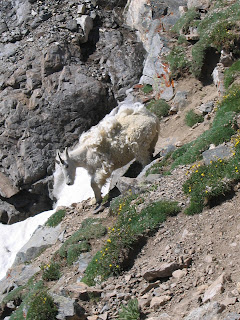
The next day we headed up to Guanella Pass, where the trail for Mt. Bierstadt starts from. The road is dirt almost immediately (once you find it... it's at the southwest corner of town a few blocks from the main square) when you get above Georgetown. It was only open towards the pass for 8 miles, but we did make it far enough to see several Bighorn that still had their winter coats (compare the white to a "normal" summer coat of brown). They had come down to the road to lick the snow salt from the road. Here are a few photos:


All in all, one of the first weekends in town and plenty of adventure.

Sunday, July 8, 2007

Grays Peak

Yesterday Ryan and I completed our 3rd official 14er; Gray's Peak. Gray's Peak is the 9th highest mountain in Colorado at 14,270 feet, and is the highest point on the Continental Divide in the US.

We drove from Ryan's in south Denver and started hiking at about 8:15 (or 8:30?). We did the standard route, a YDS class 1, which is the easiest route we have attempted so far (proven by the two guys that actually jogged the entire way from I-70... sherpa training or masochists?). The trail starts around 11,200 ft and is 3.5 miles from the summit. There seemed to be three distinct sections, so I would divide the hike into thirds mentally. The first third is surprisingly flat and required very few stops to catch breath (mind the elevation though). The second third (above Steven's Gulch from about 12,800 ft to 13,400 ft) is steeper and (not that it's a race, but nobody likes a traffic jam) provides the chance to pass groups of 6, the elderly, or those in jeans and tennis shoes. The final third is switchbacks that allow you to keep a good pace and get to the summit without putting forth a tremendous effort.

At the rock tower around 13,400, a mountain goat walked right across the trail in front of me. I was surprised to see how much of its winter coat was still on (it is July, right?), and how much shorter the summer coat was.

At that point I also had to turn around to the North and take a few photos of Steven's Gulch below. It was very green and beautifully carved. In the photo below you can see the trail crossing from center to lower left. The second photo below is Torrey's Peak, Gray's neighbor to the northwest.

Beyond this point, the remaining 900 feet of elevation gain are the third section I referenced above. From the summit we could see other 14ers including Mt. Evans and Mt. Bierstadt, Pikes Peak (seen from all our 14ers so far), nearby Torreys Peak, and Mt. of the Holy Cross. In addition to loads of other mountains, we could also see Breckenridge and Keystone ski areas as well as Lake Dillon (upper left in summit photo below).

Mt. Evans (left) and Bierstadt (right) with Sawtooth in between:

Torrey's (look how many people are on the summit as well as the trail!):

This route was probably just as busy as Mt. Bierstadt, but was much cleaner and slightly more difficult to access (the guy in the Toyota Camry that made it to the trailhead would probably agree he should have borrowed his neighbor's high clearance SUV or parked 3 miles down just off I-70).

Once back on the road we headed east to Virgilio's for pizza, which Ryan had heard about. The food was great... I'll be going back there again! We then vegged out for about 3 hours (caught up on Man vs. Wild via DVR) and eventually made our way up to the Rockies game. Dodging lightning (slight exaggeration) as we stood in line to buy tickets (hmm... is this a good idea?), we left the stadium and grabbed a few beers during the rain delay (always a good idea). The game was a good one, and the home team won 6-3. All in all, it was another dreadful Saturday here in Colorado. If this keeps up, I just don't know what I'm going to do with myself... ;)