Saturday, June 30, 2007

when the 4X4 road wins

Other applicable titles for this entry:
  • Two spares are better than one.
  • The third tire's a charm.
  • A Grand Cherokee tire is a Cherokee tire.
  • Nederland. Some days are better than others.
  • forest service road #505: 1. My '98 Jeep Cherokee, aka El Jefe aka Jasper the Jeep: 0.
The tentative goal of the day was to get to/near Arapaho Glacier, which I see out my apartment front door. After checking the map (no, not just the Atlas... the real local map) and reading about Caribou Townsite, Arapaho Glacier Trail, etc, we left Boulder for Nederland. We drove through Nederland and continued to Eldora, finding National Forest Service Road #505, which leads to the abandoned silver mining area known as Caribou and ultimately Arapaho Glacier Trail.

At this point I'd rather not discuss much about 505 except that it's more of a hiking trail than a 4X4 road, and the wise decision would have been to turn around when it felt like it was time to turn around (or for the forest service to leave the gate closed until they actually made the road drivable for the summer, but I'll take the blame for not listening to my conscience). The bad news is that a pyramid shaped rock jabbed right through my front left tire. The good news is that we didn't make it far on 505, and could see houses for most of the descent. The other bad news is that immediately after putting on the donut, the donut popped. The funny news is that the donut is now worthless, but ultimately served its purpose in getting us down the mountain (thanks for taking one for the team, 9 yr old donut tire!). I didn't hold out much hope for the donut, but thought it would at least go 10 feet without deflating. The last bad news (adding insult to injury here) is that my rear view mirror shook loose and fell off on this drive.

[...selectively skipping over me freaking out and inching our way back down the mountain to Eldora...]

I had my bike in the back of the Jeep with plenty of water, granola, helmet, etc, but was a bit apprehensive about the 20 mile ride down to Boulder, even though gravity would be doing all the work. Instead, Ryan decided to abandon the Jeep and walk with me to Nederland. Just shy of Nederland we got a ride to the Park 'n' Ride from a very nice volunteer fireman who recommended the nearly-new Wild Mountain Smokehouse and Brewery. [side note: I would like to add "liquid funds" to the list of camping essentials, because neither of us had any cash, so if we did not have RTD mass-transit passes provided by our employers we would have been SOL on getting a bus ride back to Boulder (I would have inevitably blown a bike tire as well). Also, kudos to RTD for having bike racks on their buses.] We took the bus from Nederland down Boulder Canyon to my apartment (for free) and drove Ryan's Jeep back to rescue mine.

Check out what great shape the donut is in!

I guess I'm glad I had the tent in the back, but wish I didn't have the tire in there too...
3rd tire, plus rear view comedy...

In a beautiful twist of fate, Ryan's Grand Cherokee spare tire fit my Cherokee. With all 4 wheels safely on pavement, we decided to heed fireman dude's advice about Wild Mountain Smokehouse and Brewery before the 4th of July fireworks in Nederland. The beer, food and atmosphere was great (although $9 is a bit steep for the pan-seered tuna appetizer) and we came away with two new goals; Ryan's new goal is to get a job in Boulder and live in Nederland, and our collective new goal (this has come up before but was reaffirmed tonight) is to own a microbrewery restaurant in a setting such as Nederland. The fireworks and rowdy hippies (God bless mountain towns where cell phones don't work, heat comes from wood-burning fires, and dreadlocks are as common as dogs) brought a stress-free conclusion to the day. Today was not the worst day of my life... actually somewhat comical in hindsight..., but the two deflated tires does indicate I missed the turn for Easy Street this weekend. If you include the allergic attack to whatever caused my cheeks, lips and eyes to swell after the Thai food and bike ride on Thursday, then I am hoping next week is a notch above this one.

closing argument: The '98 Wrangler and Grand Cherokee come with a full spare. Is the Cherokee the soccer mom SUV of the '98 Jeep line? That makes me mad, because I have always thought my Jeep was very functional. I pick up my real spare (w/ tire) to replace the donut for $20 from a dude in Golden tomorrow after I get the popped tire fixed/replaced (thanks craigslist). Here's hoping I don't run over a nail on the way down to Golden.

Sunday, June 24, 2007

Mt. Bierstadt & Mt. Evans

This was another 14er weekend; 14,060' Mt. Bierstadt and 14,264' Mt. Evans. [Technically, I'm only counting Bierstadt because we drove up Mt. Evans, but that still doubles the percent complete to 2/53 and means 3 times above 14,000 ft in 8 days.] As we drove up Guanella Pass (the Georgetown exit on 70) Friday night I was relieved that we

  • started from 1000 ft higher than last weekend,
  • had a more gradual ascent, and
  • had already been to 14,000 before;

all of which seemed to make this experience much easier than last weekend. We setup the tent in a nearly vacant lot under a perfect half moon and vivid milky way with the alarm set for 7:00am... only to be woken up at 5:19 by the van parked next to us. I was a bit frustrated by this but took a minute to mentally applaud their enthusiasm (... and went back to sleep). At 6:00 one of two things happened; either we travelled back in time to Shea Stadium on August 15, 1965 and tried to sleep during the Beatles' concert, or half of Denver decided to summit Bierstadt along with us. [Those playing along at home should add one point for guessing option B.] For a minute I honestly thought I was on candid camera and viewers at home were laughing at my pathetic attempt to sleep through the Rose Bowl parade. Realizing 7:00 was a pipe dream (I am NOT a morning person), Ryan and I tossed the tent in the Jeep and ate breakfast.

Overall, the hike up Bierstadt was an enjoyable 7 mile round trip adventure on a cloudless day. The boardwalk across the willows mud-swamp was greatly appreciated. There was still a fair amount of ice on the trail but not much snow on top of the ice for traction (I fell once). It took under 3 hours to get to the top (Ryan beat me by 15 minutes but I was pleased with my time), and about half that to get down.


On the summit we could see several other 14ers including Pikes Peak, Longs Peak, and in this panoramic looking West (sorry, the photos didn't stitch perfectly) you can see Grays Peak (left) and Torreys Peak, about 15% in from the right.


The image below shows the Sawtooth, which is a bridge between Bierstadt and Evans, and Longs Peak in the distance.

Panning to the right from the Sawtooth, you can see Mt. Evans.

Here is a shot of both Bierstadt (right) and Evans (left) from the trailhead:

To be honest, I had a great time but a few things affected my enjoyment of this hike:

  1. The crowd (am I a solitude snob or just a jerk?). When we drove away after our descent there were cars parked on either side of the parking lot for several hundred yards.


  2. The lack of preparation (ignorance?) by the crowd. Folks, a 14er is a 14er. I don't think shorts and tennis shoes is a good idea... Neither is forgetting (or deliberately abstaining from?) water. I couldn't hike a flat 7 miles round trip at sea level without getting a little thirsty, and nobody could hike that at 11,500 ft (don't forget 2,500 ft of elevation gain for good measure) without getting parched. And clean up after yourselves. When I got back to the parking lot I had a true fist full of granola/Power Bar/Clif Bar wrappers, twisty ties (bagels or a loaf of bread?), kleenex (if you're going to be rude why not just tear up some 20 year old tundra grass and sneeze into it while you're at it?), etc collected from the trail. That's ridiculous.
  3. The view. It was quite impressive, but I think I was spoiled last weekend.
  4. I might also attribute the degree of difficulty as well. On a 1-10 scale for difficulty, if Huron Peak was a 7 or 8 then Bierstadt would be a 3. [If, however, you threw in the Sawtooth and Mt. Evans, that number would go way up for time pressure (add on maybe 4 hours?) and technical savvy for the Sawtooth... stay tuned for that one.]

After we made it back to 70 we drove east for about 10 minutes for Mt. Evans and the highest road in the US. This picture shows Bierstadt (above center) from the Evans summit.

We stopped on the way down to see the famous Mt. Evans mountain goats and then headed to Idaho Springs for Beau Jo's pizza and Tommyknocker beer.

Look how small the youngest one was!

It was another great Fri night > Saturday combo for me. I think this day would be an easy introduction to the 14er club for anyone acclimated to at least 5,000 ft. Next weekend is anybody's guess at this point, but I'm pretty sure you can count on mountains :)

Wednesday, June 20, 2007

Birthday hike in the Flatirons [catching up]

This post takes us back two months to my 26th birthday, which was 5 days after I moved to Boulder. I wanted to post these pictures to catch up on previous weekends where I actually remembered the camera (Before the Huron Peak hike I forgot the camera two weekends in a row).

I started by parking near Baseline Rd and 7th to wonder into Chautauqua Park (I did not know until researching that Chautauqua apparently means educational adult summer camp) and see how close to the Flatirons I could get before I needed climbing equipment. I hiked for about 30 minutes to get to the top of the First Flatiron, which was clearly marked. I took the following pictures (click for actual size) looking down on Boulder:

Notice how bare the trees are near the CU campus... it's rained a lot since then, and everything is very green.

I was surprised to find there are steps enabling you to walk up further than where the climbing routes begin. I stayed for quite a while on an exposed outcroup to enjoy the sun, which eventually was hidden by clouds.

The split to the Second Flatiron is not far down from the base of the First Flatiron, so on my way back I decided to also go up to the Second Flatiron. That is a bit more strenuous, but still not terribly difficult. The view into the canyon separating the Third and Fourth Flatiron was very pretty. Here is the Second Flatiron:

And looking left to the Third Flatiron:


Despite not being able to spend my birthday with family or friends, it was still enjoyable. This was a welcome introduction to my new home.

Sunday, June 17, 2007

Huron Peak / Aspen weekend

This is my first Blogger post, and it is one that I write with great joy... and sore calf muscles. All the photos from this trip (not just the ones below) will be on Flickr as soon as my Yahoo account transfers (too bad they're closing down!). I'll try to keep the tangents to a minimum, but I am not really sure how this will all come out (I have a hard time leaving details out so I apologize in advance for the novella), so without further adieu, here goes:

I've lived in Boulder for almost 8 weeks. [As those who know me will recognize, I am incapable of telling a story without a precursor, so this is the obligatory precursor.] I've heard it takes 6 weeks to get acclimated to 5,280 ft above sea level in Denver, and I feel well acclimated to that after moving from Austin, TX. Since moving here, I have spent several weekends at varying elevations attempting to acclimate to higher than 5,280 (hiking up to lakes at 10,500, driving Trail Ridge Road to over 12,000, etc). Ryan and I hadn't been higher than 12,300 ft, but after an REI session about how to climb 14ers, we decided this was a good weekend to try for our first 14er... Huron Peak southwest of Leadville. For route and photos, see 14ers.com's page.

We planned on leaving from Ryan's (near the DTC) as soon as I drove down from Boulder... the assumption being that we would get to the trailhead around 10pm for a 7am start up the trail. An emergency surfaced at work around 4:45 and kept me in the office until 7:30 (perfect timing... pinche trabajo!), so it was closer to 10pm by the time we got on 70W and out of Denver (not anywhere near the trailhead or preparation for the hike). I was extremely frustrated about the "work emergency" and continued to agonize as I wished we could see the mountains instead of the stars when we exited 70 at Copper Mtn and drove through Leadville at midnight. [sidenote: we listened to Radiohead most of the way from 70 to the trailhead... this is relevant later] Chaffee County road 390 to the old mining/ghost town of Winfield was a piece of cake. The final 2 miles from Winfield to the Huron Peak trailhead, however, were technical four wheel driving (do NOT disregard the signs about high clearance 4WD required) and were especially interesting at 1am. I was somewhat jealous that it was Ryan's weekend to drive, knowing my Jeep was parked in a garage 5000 ft below, but that jealousy was replaced by further anguish when I gashed my left thumb on a tent stake. I didn't even notice until I saw the blood that had smeared on my hand and all over one of Ryan's (sorry dude) tent poles. [side note: attempting to focus on the task at hand, Radiohead's Lucky lyrics were all I could think of... "It's gonna be a glorious day, I feel my luck could change"] It was 38 degrees (the trailhead is at 10,500), the tent was not exactly on flat ground, and the 7am wakeup was not my idea of fun, but I was in the mountains and the stars were fantastic, so I felt about as good as possible given the situation.

The next morning we packed up and ate breakfast quick enough to get on the trail at 8:40. I knew from the 14ers.com report that the steepest part of the 3 mile hike was the first half (a series of switchbacks to the treeline at 12,000 ft). Hikes that start out difficult usually kick my butt (such as the Smokies trip 1 yr ago to the day), and this was no exception. The dog vomit we passed told me I wasn't the only one struggling. I definitely slowed us down, but was relieved to eventually discover that it was my being out of shape and not the altitude (if I was huffing and puffing at 12,000 how the hell would I get to 14,000?). I also stopped periodically to take in the incredible scenery, which was incomparable to anything I had ever seen before. [sidenote: as the thought of me not dealing with the altitude spun through my frontal lobe I once again came upon Radiohead lyrics that seemed to subdue the concern... Optimistic "If you try the best you can, The best you can is good enough"... it better be or I am going to feel like an idiot] Once we hit the treeline the caffeine in my 
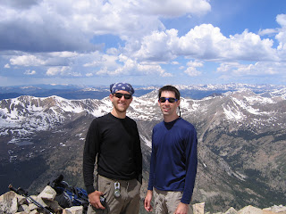
GU gel (or was it the lack of oxygen? or the fact that I subconsciously expected a cakewalk from here to the top having read that in a review? or maybe just simple old Rocky Mountain High) left me suddenly elated (loopy was the word I used to explain it) and our pace increased. At this point we also passed squirrel entrails and bear (or a huge dog - there were lots of dogs up there) scat. When we came to the basin (pic #4 in the 14ers.com route description) we lost the trail a bit and postholed up to the thigh in snow attempting to avoid stepping on the tundra. Snow got into my boots, but my SmartWools and Sundowners did not disappoint (no blisters!). Once we got back on the trail, the stretch from 12,000 to 13,000 became strenuous due to the thinning air. As we approached the summit, I began to feel much more acclimated and ended up passing Ryan who struggled a bit with altitude (again, I was hardly going fast, but at that height not stopping to catch breath seems to increase pace dramatically). We made it to the summit at 11:30, a little after our target but early enough to avoid the late afternoon storms. The view simply cannot be put into words.

I did not realize this, but Huron Peak happens to be one of the best places in the state to view other 14ers. From the summit we could see at least 15 other 14ers including
The San Juans (~75 miles away direct) were also visible. Directly across the valley from us were 
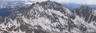
The Three Apostles (click the image below for larger view; see also Collegiate, Sawatch and San Juans in the background).

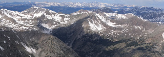
Looking a bit north from the Three Apostles (cardinally West), we could see the Taylor Park reservoir on the other side of the Continental Divide. The Elk mountains (and, I believe, most of the popular ski resorts between Snowmass and Vail) are visible a bit north of there, as shown in the picture below.

Looking to the north we could see Mt. Elbert, which is pointed out by the red arrow in the pic below. La Plata is the highest point on the left.

We stayed on top for an hour to eat lunch and take in the view. Storms began to role in after noon (right on queue), so I was glad we had made progress towards the Jeep when lightning sporadically clapped above us. As we descended we both struggled with altitude, but with each measurable decrease in altitude the air felt noticeably thicker (I never thought I would say 11,000 ft felt like thick air, but it did very much compared to 14). About a half mile from the trailhead the clouds finally brought rain and sleet. The falling ice was pretty cold and about penny-sized, so we put our rain coats on... just in time for it to stop. We reached the Jeep at 2:30 with wet clothes and fully oxygenated lungs 3,500 feet below Huron. This was easily in the top 3 of most physically demanding days I've ever had, and is #1 on toughest 3 miles hiked. If it were any more than 6 miles total it would top the most physically demanding list.

Leadville produced much-needed food (burgers and chocolate milk to get the fat and protein levels back up). We took Independence Pass to Weller campground (highly recommended!) just east of Aspen. After we put the tent up we realized the sun wouldn't set for another hour, so we drove to Aspen for a Fat Tire. I forgot my Tiffany tennis bracelet (a fashion disaster!) and smelled awful, so I felt a little under par compared to the rest of the Saturday night Aspen crowd, but it was a great time in a great town. [sidenote: the Jazz fest is next weekend and I would pay $100 to see Herbie Hancock if it wasn't on a Thursday night... that sucks!] I slept like I hadn't caught a wink since March. The next morning we headed up to the Maroon Bells.

4 years ago I parked right in front of the lake; this is now not possible. It was annoying to drive back down for the bus after the ranger told us this, but I swear the area was more pristine (if possible), and I applaud the change. I pondered Colorado's population concerns and mass-transit on the way (back) up (would John Denver be happy or concerned that I was in Aspen?) the canyon. The bus driver gave us and explanation of the geology and history of the area as we went. The Bells were a tremendous sight on a cloudless backdrop.

We walked up to the head of the lake and saw a mountain goat on a cliff. After that it was time to head back to civilization. What an incredible 24 hours!

As we drove down towards Glenwood I became a bit melancholy over the increased population of Basalt and Carbondale (very noticeable compared to four years ago) then realized I was just like them by moving to Boulder (pointing the finger back at myself increased the melancholy)... similar to the way I felt when driving into Jackson, WY (also four summers ago). Let's just say I have mixed emotions or concerns about the issue (and being part of it), and wish there was a way for everyone to enjoy the mountains without filling the valleys. The traffic into Denver re-surfaced the thought a few hours later, but I could think of nothing but the awe-inspiring aspects of the weekend as I drove towards the Flatirons from Ryan's apartment. I navigated to John Denver on the iPod for good measure (mom would be so proud; Sharon, are you still reading?) and wondered how many people truly understood the Starwood in Aspen lyrics ("my friends are the snow covered hills"). You better believe Rocky Mountain High and I Guess He'd Rather Be In Colorado also made the playlist.

This weekend is why I moved from Austin. May the LORD strike me dead or make me visit Missouri if the sights or events of this weekend ever become ordinary.