2006-06-11 - 2006-06-15
Summary
This is a 5 day hike through eastern Great Smoky Mountains National Park, primarily on the North Carolina side of the park. The 54 mile loop starts and ends at the Cosby Ranger station. Highlights include 9 miles of Appalachian Trail including some of the highest points in the park, dramatic elevation changes, and some of the most secluded trails in the park. Overall I would rate this as moderate to strenuous with patches of easy. Those with bad knees may want to reconsider, and those wishing to test their uphill endurance should make reservations immediately. So let's dive right in...
I'll remember this little adventure as the one where I checked the topographic lines but didn't really… and made a fool of myself in the process. The graphs will prove I clearly didn't have luck finding a five day version of the classic Smokies "up and back" triangle route (where you drive into the park late Friday night, hike up to the AT Saturday, take in as much of the AT as possible on Sunday, descend Monday morning to the car on a different trail than you took up, and get home Monday night). Despite my mishap, however, this route was a diamond in disguise.
The day charts are not drawn to the same scale. They are the same width but not the same number of data points, thus making days with fewer data points seem more gradual. The final graph is to scale, with each tick on the X-axis representing 1 mile. Follow along at http://home.nps.gov/applications/parks/grsm/ppMaps/GRSM_Trail%20Map%202005.pdf.
Day 1

We camped in the Cosby campground and headed out in the morning, so getting to the trailhead was easy. There were surprisingly few vehicles at the Gabes Mountain Trail trailhead parking for a summer weekend. This was clearly not going to be like a walk through Cades Cove or up to Clingmans Dome. The seclusion, the news that campground #34 was closed due to bear activity, and Albright old growth trail I'd read about had me excited for day 1, not to mention the whole trip. Since I was out of shape and knew it, these 13 miles were the ones I was concerned about. I had correctly detected the 2000 foot elevation gain coming after lunch. The trail started out easy on me, though, and that was welcomed. A Boy Scout group joined us at Hen Wallow falls but didn't follow us any further. I honestly cannot remember much about the morning except that campground #34 looked like a great site. Despite failing to produce a bear for us, it made a good lunch stop. We strolled over 4 easy miles to Maddron Bald Trail and then the fun began. It was early afternoon when we made it to Albright Grove Loop Trail. I had definitely worked up a good sweat already and still had more than half the elevation gain ahead of me. I think I was focused on that too much to appreciate the old growth, but I would still recommend taking the side trail over staying on Maddron Bald Trail. The march to campground #29 (Otter Creek) wore my lazy butt out. #29 is small and not very flat but a good water source. By the time I got there the skies had commenced a sprinkle which became a downpour as soon as we had the tent up. The rain made for a quick dinner and early bedtime.
Day 2
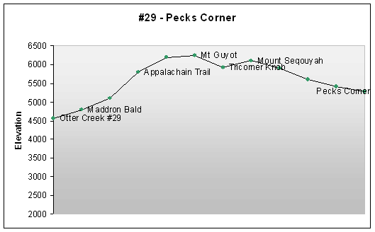 We woke up pleased to be dry and foolishly expecting a shorter, relatively flat day (my fault). Just checking beginning and ending elevation yields a net gain of 500 ft, but a closer look yields another 1700 ft climb before lunch. Lesson learned... somebody needs to steal the map from Brett. [Side note: This actually is the flattest day of the trip if you sum the absolute elevation deltas for each day (see chart below).] The sky was overcast, but right at Maddron Bald the clouds cleared up and I took a minute to enjoy the view. After that, it was a head's down mission to get to the AT - easier said than done for an out-of-shaper like me. When we made it to the AT we celebrated, snacked (but decided to eat lunch somewhere further down the trail), and rediscovered the "smoky" AT. Apparently everyone else got the memo about bad weather, because the AT was surprisingly low in traffic. It's a good thing, though, because I would have looked like a train wreck. The group split up due to non-agreement about whether to take the primitive trail to Mt. Guyot (the 4th highest point in the Southern Appalachians, 2nd highest point in GSMNP, and the highest point on this trip) and agreed to reconvene for lunch at Tricorner Knob. I never saw the primitive trail and was stumbling through the pines beginning to welcome my newfound empty-stomach induced delirium (the temperature is much lower in dense pines without the sun... it's kind of like a nice buzz after a while… learn to enjoy it like Hunter S. Thompson would have... but where the hell is Mt. Guyot... did I just say that out loud?) when I (still believing Tricorner Knob was miles away) eventually broke down and started gorging on lunch (my excuse for stopping was shivering and needing a fleece). Ryan backtracked for a few minutes to find me and bring good news about our progress. Tricorner Knob was close by. I packed up and finished lunch down the hill. The sun broke the clouds up past Mount Sequoyah and revealed great views. The Eagle Rocks area is definitely a site to see. Overall, this is a very pretty stretch of AT, and I was a little bit sad to see it go when we headed down to the Peck's Corner shelter on Hughes Ridge Trail. That night we woke up to strange noises which we eventually concluded were a wild hog. I didn't even know there were wild hogs in the Smokies, but it definitely didn't sound like a bear, so there you have it.
Day 3

Day 3 came easy after finally being forced into shape (or at least enough so) by the trail itself. Or was it that day 3 actually was flat? After all, it's just a 10 mile cruise down to 5040 ft. from 5280. Wrong again... almost all the elevation lost before lunch is quickly made up getting to campground #44 [Somebody needs to club me for lack of topo reading skills. Lesson learned a second time. Oh well…at least we're used to the elevation changes by now]. The first several miles were a very gentle descent of Hughes Ridge. Although not dramatic and exposed like AT ridges, I thought Hughes Ridge was interesting because it was very narrow. Vistas to both right and left are revealed when the leaves aren't too thick. Turning left onto Enloe Creek Trail brings a steeper descent and lesser maintained trail (as in not being able to see your boots when standing in the middle of the trail). Somewhere on this trail before we bottomed out at Enloe Creek campground (#47) we realized we had seen nobody since leaving Peck's Corner. An older couple did join us for lunch at (the now replenished and roaring, due to the past few nights of rain) Enloe Creek – thank God for the foot bridge. Those were the only people we saw on the trail that day. After filling up our water bottles, we ascended Hyatt Ridge to McGee Spring. The final mile follows the edge of the ridge and is a good chance to look out over the valley Jones Creek flows through. Eventually the trail leads to a large, flat opening with soft ground to put a tent on. We arrived fairly early in the afternoon, so there was plenty of time to hang wet clothes, build a fire, get water and take in the quiet. The solitude and silence at camp that night was almost overwhelming. I convinced myself this must be one of the least used campgrounds in the park (although apparently horse traffic is high in the summer). Although there is a gravel road a few miles away, it's a long hike from a ranger station or paved parking. If I'm back in this part of the country on a new moon again, I now know where to head to catch the stars.
Day 4

After a relaxing night's rest, I was curious to know if we'd see anybody on day 4. I checked the map and discovered that I had yet again underestimated the afternoon's climb. By this point the running joke was old and I decided to let the mountains do their worst on this shortest day of the hike. I don't remember much about hiking Beech Gap Trail except that the Round Bottom bridge construction (look – people!) forced us to wade through Straight Fork at the bottom. We filled water bottles and prepared for the steepest (consecutive gain) two miles of the trip. Balsam Mountain Trail was a mixture of vegetation with several good vantage points. Before arriving at Laurel Gap shelter we came through a seemingly out of place stretch of spruce-fir (ahh yes, back to this elevation again...), and then arrived well ahead of anticipated schedule even with the “1700 ft drop followed by a 2400 ft gain over 8 miles” elevation ride. All told I don't think we saw more than a half dozen people on day 4, including 3 guys that stayed in the shelter with us. Day 3 and 4 combined were much less physically demanding than the first two days for me, and I felt like I was finally catching my stride only to realize tomorrow would be the last day of the trip. I'm tempted to suggest that more avid groups could combine day 3 and 4 together (from Pecks Corner to Laurel Gap in one day), but that would be a fairly challenging 17 mile day with much elevation gain and loss for most folks. The time saved from going shelter to shelter (i.e. no tent teardown or setup) and carrying one less day's worth of food would help make that possible.
Day 5

Day 5 was actually just a half-day even though we packed in 11 miles before lunch. The rationale for that was to get to Carver's Applehouse Restaurant in Cosby. In my opinion, it was well worth it. In order to do this, I highly advise filling up water bottles to the brim and having a solid breakfast before leaving Laurel Gap (use the time you would have spent taking down your tent). All told that morning, we lost 2400 ft, gained 1100 back, and then lost the final 1800 ft over the course of 11 miles. [Side note: I'm thankful this was not day 1 for me. If we had decided to do our trip in reverse I probably wouldn't have made it to Low Gap without my ceremonial overexertion vomit... yes, I'm an idiot. Apparently this reverse direction is rated moderate, but it seemed fairly steep hiking down it.] From Laurel Gap, it's basically a steady drop all the way down to 3000 feet. The Gunter Fork cascade is a nice landmark to stop and rest your knees. We were delayed a bit by having to wade across the creek near campground #36. The water was very high due to several days of rain so we could not find a good dry crossing. I imagine this is frequently the case, so bring sandals and be prepared to wade here. At #37, we had a quick snack before the final push to get us up and over the AT. I have to say that I didn't take the time to stop and appreciate the Low Gap trail, but it was very pretty. It's quiet, heavily wooded and well maintained. It also provided the two steepest miles (1100 gain, 1100 loss) of the trip, so I was more focused on lunch than the trail's aesthetics. It was a short hike down to the car once we made it back to the AT. We drove to the laundromat / shower (they probably would not have fed us at Carver's without the shower) and had a fantastic lunch in a beautiful setting. Out of the Smokies and on to Bonnaroo. What a great week!
Total trip data

Topographic data are rough estimates from Trails Illustrated / National Geographic Great Smoky Mountains National Park Map and
latitude / longitude data comes from Google Earth.
| day | mile | elevation | elevation delta | latitude, longitude | point of interest |
| 1 | 0 | 2400 | lat=35.7494659424, lon=-83.204208374 | Cosby Ranger Station | |
| 1 | 2650 | 250 | |||
| 2 | 2800 | 150 | Hen Wallow Falls | ||
| 3 | 3250 | 450 | |||
| 4 | 3240 | -10 | lat=35.7485733032, lon=-83.2490234375 | Sugar Cove #34 | |
| 5 | 3100 | -140 | |||
| 6 | 2750 | -350 | |||
| 7 | 2500 | -250 | Maddron Bald Trail | ||
| 8 | 2750 | 250 | |||
| 9 | 3100 | 350 | Albright Grove Loop Trail | ||
| 10 | 3500 | 400 | |||
| 11 | 4000 | 500 | |||
| 12 | 4500 | 500 | |||
| 13 | 4562 | 62 | lat=35.732131958, lon=-83.2557373047 | Otter Creek #29 | |
| 2 | 14 | 4800 | 238 | Maddron Bald | |
| 15 | 5100 | 300 | |||
| 16 | 5800 | 700 | Appalachain Trail | ||
| 17 | 6200 | 400 | |||
| 18 | 6250 | 50 | Mt Guyot | ||
| 19 | 5920 | -330 | lat=35.6940422058, lon=-83.2563781738 | Tricorner Knob | |
| 20 | 6100 | 180 | Mount Seqouyah | ||
| 21 | 5900 | -200 | |||
| 22 | 5600 | -300 | |||
| 23 | 5400 | -200 | |||
| 24 | 5280 | -120 | lat=35.6508712769, lon=-83.3084030151 | Pecks Corner | |
| 3 | 25 | 5200 | -80 | ||
| 26 | 5300 | 100 | |||
| 27 | 4850 | -450 | Hughes Ridge Trail | ||
| 28 | 5000 | 150 | |||
| 29 | 4800 | -200 | |||
| 30 | 4800 | 0 | |||
| 31 | 4000 | -800 | |||
| 32 | 3620 | -380 | lat=35.6111373901, lon=-83.2546463013 | Enloe Creek #47 | |
| 33 | 4500 | 880 | |||
| 34 | 4900 | 400 | |||
| 35 | 5040 | 140 | lat=35.6397361755, lon=-83.2401046753 | McGee Spring #44 | |
| 4 | 36 | 4900 | -140 | ||
| 37 | 4250 | -650 | |||
| 38 | 3400 | -850 | |||
| 39 | 3200 | -200 | Round Bottom | ||
| 40 | 4250 | 1050 | |||
| 41 | 5070 | 820 | Balsam Mtn Trail | ||
| 42 | 5500 | 430 | |||
| 43 | 5600 | 100 | lat=35.6654701233, lon=-83.1875610352 | Laurel Gap | |
| 5 | 44 | 5400 | -200 | ||
| 45 | 4750 | -650 | Gunter Fork Trail | ||
| 46 | 4000 | -750 | Gunter Fork Falls | ||
| 47 | 3500 | -500 | |||
| 48 | 3100 | -400 | |||
| 49 | 3000 | -100 | lat=35.7180099487, lon=-83.1658630371 | Lower Walnut Bottom #37 | |
| 50 | 3100 | 100 | |||
| 51 | 4200 | 1100 | Low Gap (AT) | ||
| 52 | 3200 | -1000 | |||
| 53 | 2600 | -600 | |||
| 54 | 2400 | -200 | lat=35.7494659424, lon=-83.204208374 | Cosby Ranger Station |